Sunday – Rockhampton, Queensland
Back home finally 🙂
Well, a bit of a bonus, the brekky at the motel was great, a good old fry up, nothing like a full stomach to start the day. I had a few more caches to look for during the ride home, the first one was at the local botanical gardens, but as it looked to have been affected by recent flood waters I did not bother looking, I can do that another day. Crossing the Nogoa River bridge, the last time this was flooded I was out here with the SES(State Emergency Service) and we had to cross the river by train. The water level was up to the red line on the train bridge and the one I am on was under water, this was a few years back now. At the time it was quite interesting crossing raging floodwaters at night to help the townspeople 🙂


Heading east there is a small weird place of interest, a cache was placed here to get people to stop and look 🙂 I have no idea what this place is about, needless to say, a lot of bones and old boots and I doubt I would like to go for a dip!


Not far east of here is the small town of Comet. Once again, I have been through this place many times and only stopped at the pub 🙂 This time, due to another hidden cache, I had a chance and the time to look a bit further. I spotted my first cane toad here since being back in Oz, these are an ugly critter and have slowly taken over the land.

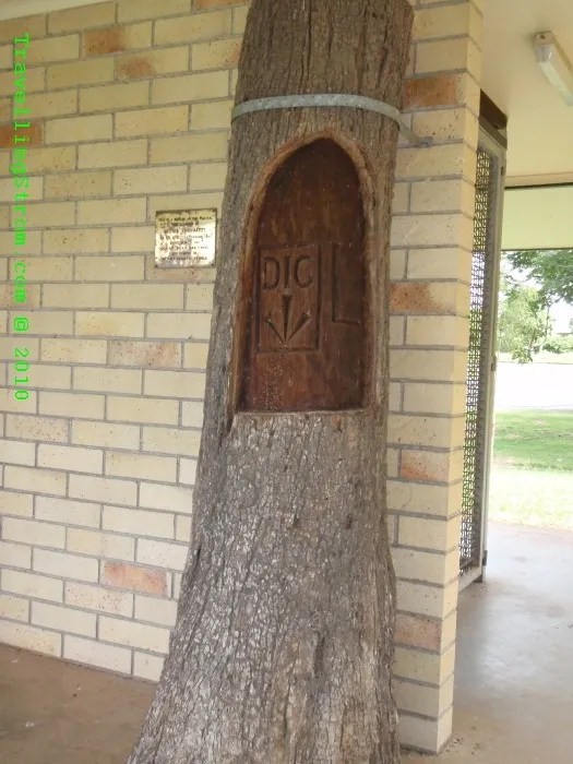
They have poisonous glands on their back and shoulder and a lot of native species die from them every year from trying to eat them, although some have managed to work out how to eat them. The crow has a trick of flipping them over on their back, then eating them through the belly 🙂 Humans on the other hand have worked out a different use for them, they dry them in the oven and smoke the result, apparently they get high from this, one of the many things in this life I have not tried yet and am not planning on doing so any time soon 🙂 Back to some other history, this town is famous for having a DIG tree here. Basically the explorer Leichardt left some notes and stores here and buried them, with the tree engraved with the word DIG and an arrow pointing down.

After that, I stopped at a few more caches before it started to rain. By now I was getting a tad hungry so I stopped at the Westwood pub for lunch, this is a cow cocky’s type of pub, with the old swaggy out the front and they make no bones about which is the men’s dunny 😉


After a nice burger I headed off and as I got near Stanwell power station, I saw the result of a coal train derailment, there had to have been some powerful force to rip them wagons apart! It must have been a while back as they were neatly stacked by the tracks and the line was open and working again.


The spitty rain got heavier the closer I got to the coast, as is normal, and when I stopped for a cache near Neerkol, it became quite heavy. This place has a darkish history, a lot of young pommy orphan kids were brought up here after the war but there have been many reports about abuse by the people running the place, this is not the only place like this in this country though sadly, a dark chapter 😦


A short time after this I arrived at the roundabout to enter Rockhampton and to be met by a bulls arse, what a silly idea 🙂 Both the south and west entrances to this roundabout sees a bulls arse, but the eastern one, for when you leave Rocky, you get to see the bull head on, hopefully there is no hidden meaning in that 😆

There was much evidence of the recent rain events that has been happening in the Rocky area over the past few months, with the Yeppen Lagoon overfull of water again and probably crocs as well. Past the Tropic of Capricorn tourist centre, (which is not actually on the exact location of the tropic, but close enough for a sheep station eh!). The barrage gates on the river were fully open allowing a brown torrent of fresh water and silt to head down the Fitzroy river and out to sea, but the car parks were open and unflooded, so that was all good 🙂


And after a short stop for a beer at the Fitzroy Hotel to say g’day to some old friends, I headed back to my folks place and the official finish of this leg of the trip. 🙂
The next leg will not be for a while as I need to save up for beer money, but the basic plan will be to ship, probably by air, the bike and me to the Europe somewhere, then ride it east through to Singapore and ship it from there to Oz, and ride it home. I have no real plans at this stage as to timing, but the next stage will take a lot more planning, because a lot of the eastern part of Europe(not the EU countries) will require me to have visas and carnets. They only have a short life span and cannot be had too far in advance, so there will have to be a more ordered approach to the trip.
I have really enjoyed my time on the road over the past few years and loved meeting the people I did, as well of course the different cultures, even if they created a challenge at times 🙂 For those who followed along and read my daily ramblings, thanks for being there and for the emails as well. It was great to hear from people I had met, or had yet to meet as well as tips and ideas of where to go and what to see.
My web page will be a bit static from here on in, but I will be experimenting with a few more ideas for the future 🙂 I will put some numbers up though, once I have collated them, things like fuel used, total distance etc etc
Day – 301 km and 187 miles
Trip – 10,193 km and 6,334 miles
Cheers
TravellingStrom
WORLD 
