Thursday – Death Valley, California
Well, no wild animals or Aliens came and ate me so I survived my first camp out 🙂 And I was up at sparrow fart, which is amazing as most of my days have been sleep ins. Would I survive the day down there in the cauldron, especially with the dirt roads and snakes etc, who knows, read on 🙂
I had read the map of the area yesterday and had decided what I would like to achieve today. Yesterday was just a basic look around to see what was doable. As it was going to be hot, I needed to be on the road early, especially as I was just under an hour from the start point. I only have a PDF map which is too hard to render properly, if you want to download one and look it is here and 1.2Mb in size. It is better than me trying to cut one up and post it. Otherwise it will be just names and mean nothing.
Sun up at Camp TS and the flower lined road down into the valley


From over 5000ft to sea level in 30 minutes 🙂

Right, first point of call is right back where I started from nearly?? Near Beatty at the entrance on the right hand side is a dirt road that goes down to Titus Canyon via a ghost town called Leadfield, it is one way only and I wanted to do it. I headed off and because I was at half tank, I ended up going all the way back to Beatty via Mud Canyon,it was only another 8 miles to fill the tank.

On the way a bit further I spotted a dead road kill, a snake, so I went back for a look, only it was still alive by crikey!!


It had been run over but as I pulled up next to it, it started to move towards me, which was a bit scary, an injured angry hisser! Anyway, I kept rolling backwards and it eventually moved off the road, so maybe it survived, I hope so anyway 🙂 I think my stopping next to it was a help, instead of letting it get another hit after the first one. In the 2nd slightly blurry shot there is a dark mark to the left of the head, that is blood and stuff, but it moved slowly and surely away.
Anyway, next stop Beatty for fuel, then I came back in and started down the track, well when I say start, I mean a pussy attempt at a start, I chickened out right away as the sign said “High Clearance 4WD vehicles recommended”


That plan was dust, so the next one was to go see a big crater called Ubehebe up in the top left, near Mesquite Springs. First stop was daylight pass, where I had to stop for a pass 🙂 I had been hydrating all morning and it was having an effect, but it gave me a chance to add some energy food which I was going to eat in the canyon. Never mind, I had to finish them all as I was going to be in the heat soon and chocolate melts you know


The road sign yesterday advising of flash floods is very evident here with road damage and lots of erosion across the valley floor.


Self explanatory

Just after here was the exit of Titus Canyon, it is two way for a few miles to the canyon itself. So, I went for a look, all of about 200 yards as it was too corrugated and loose etc, once again, I chickened out. It was a real pain just turning around without losing my footing, but I got there in the end, about a 100 point turn I think, lol.


I eventually arrived at the crater, this had been blown open a few thousand years ago and is quite fresh. There was a walk up the hill to a smaller one and a rim walk. I saw someone on the other side as I was walking up the hill, and in the end I decided to do the whole walk.


The erosion down into the crater.

The track(?) up to the top

The view from above and the track around the rim as well as little Hebe.


Some flowers for the girls.


My bike across the way 🙂

Having a rest, appropriate shirt I thought 🙂

A little further and I get back to the bike at last.


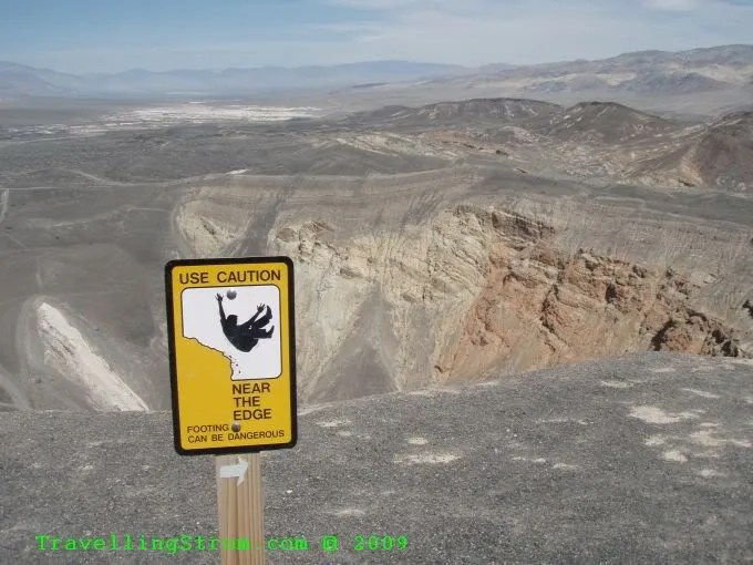
Did I mention the wind, it was blowing a gale, at least 40 knots with stronger gusts as well, it made straying near the edge a bit scary, and the signs were everywhere and except for where I sat down, I did stay away.
I spotted some yellow weed on the bushes all over, reminds me of the red weed I saw in the Aussie outback.

Next stop as it was near midday was just back up the road a few miles called Scottys Castle. I had a snack here and a rest from the heat.

Death Valley Scotty was a spruiker who managed to convince people to loan him money etc on account he had a big gold mine, he lied! This was built back in the 30s and cost $2M back then, pretty impressive stuff. It was at a slightly higher elevation and had a water supply. Unfortunately, people planted foreign trees etc, so it is not as natural as it should be. Still good though.


This is the original shed, it is just about had it.


The solar power plant.

More flowers on the way up the hill to see Scotty’s grave site.


On the way back down I spotted one of them lizards that swap between feet as it gets warm
Here let me zoom in a bit 🙂

A couple more of the outside


Then the power plant room, quite high tech for them days.


More flowers, it is spring you know 🙂

This is for Todd, he said keep an eye out for pretty rocks, well here they are 🙂

I asked and had a chat with the local Emergency Medical Technician called Bob. I wanted to ask him how they manage dehydration out here. I had noticed very little warnings around and nothing in the dunnies about urine colour, which is an indication of dehydration etc.

We spent some time inside the wagon chatting about various things that happen out here. One thing happened about 4 years ago, a patrol car was following a motorcycle with pillion, and just suddenly she fell off! She died from head injuries, no helmet, but the driver said she was hot and flushed and did not want to drink anything, this is the first signs of heat stress, so they should never have kept on going. Apparently, all the people that go through here are elderly retirees, who travel through in aircon vans, Rvs, cars etc, have a cup of coffee and no water at all, then when they get out the car and walk in 50C temps, then they keel over.
The upshot was, I had mentioned the urine charts and he asked if I could score one for him. Well, after I emailed Peter from SES, he sent me one right away and I forwarded it on, so maybe in the future, the urinals will have this on prominent display with fewer collapses as a result. This is the chart I am talking about, every mine site in QLD usually has one of these, I also carry one in the SES.

It was now near 3pm, so I thought I would head to the visitor centre for another look at the displays, it was still quite hot of course, and the wind was not really cooling things down. I was quite hydrated and actually riding like I was in this heat was no big deal as I knew that within an hour, I would be somewhere cool to have a rest. Back home in this heat, with nothing in between to stop for, I would have been off the road by now. There is no shade out here by the way, no trees really, some in certain spots, but most of the scrub is knee high.
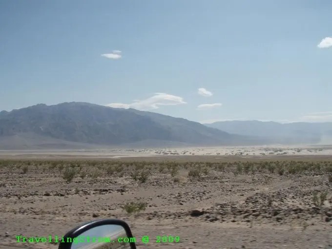
Some of the views from the valley, you can see the dust storm starting near the dunes, quite scratchy on the face!


After getting halfway to Furnace Creek, I decided why bother, I still had to go see the kilns and they were an hour in the other direction, so I turned around and had a rest break at Stovepipe wells and chatted with some people there.


It was now 4.30pm and I started back up the mountain where I knew it would be cooler. You can see the rain erosion in these hills where the flash floods occur.


More flowers for the girls.


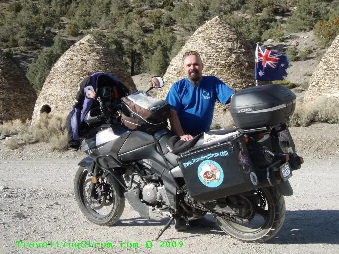
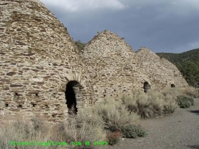
Now, the kilns were past my campsite, I stopped to top up with water as I had just run out, that was 4litres done for the day. This road is past Stovepipe Wells, past Emigrant and you can see Wild Rose in the bottom left of the PDF map. The last bit of road was dirt and if I had known it was going to be so bad I would have given it a miss. As it was uphill though, I was sort of committed; I did not want to chance a drop by trying to turn around here. Very corrugated once again and loose stuff and holes!

But after 2 miles of bone jarring vibration I got there and parked in a way to get out, that is facing downhill 🙂


Now, of course the road I went up, I had to get back down, lol, but this was a bit easier as I could freewheel down in gear and not use power like I had to uphill.


I got back to camp just on 6pm and started to sort some food out as I was peckish. I also then made a fix on my Garmin GPS marine mount which had broken today. A bit of glue and some cable ties, hopefully that will be a fix that lasts a while. I need a proper mount like Touratech, but very pricey, let’s see how long a few cable ties last 🙂


After dinner and a chat with my neighbours from Oakland, near San Fransisco, I had not much to do except read a book. The pute was down on power and no charger for it yet, so another quiet night, except the fly boys were back, 4 of them this time, after they nicked off it was time to turn in after a full day of riding in the heat. Of course, up here once the sun went down, it got quite cool, down about 10C overnight at a guess. It was beaney time anyway and another early start as I wanted to do the Badwater area, which is the lowest point in North America
Day – 262 miles and 422km
Trip – 4,018 miles and 6,466km
Cheers
TravellingStrom
Go to top of page