Piew Cave, Mhong Bomb Village and Other Tourist Attractions Near Phonsavan
Posted by TravellingStrom on November 25, 2012
Mayan Prophecy Countdown
[gigya src=”http://www.clocklink.com/clocks/9001e-green.swf” flashvars=”TimeZone=GMT1000&Target=2012,12,21,12,00,59&Title=The End is Nigh” width=”288″ height=”24″ wmode=”transparent” ]
After a day of blogging yesterday, I had planned on doing the same today, but the electricity kept going off and the internet was down, so I decided to head off instead to Vang Vieng. But I was thwarted by my lack of available cash!!! I needed to pay my bill, plus buy fuel and both ATMs I tried were stuffed. It was Sunday and last night there were a lot of party dwellers around, so maybe they had run them dry? ❓ Or more than likely the lack of phone service was the issue as my phone was also having problems connecting with the net. After using my last 50,000kip to eat breakfast I figured I would have to wait until tomorrow, so what to do? As I walked past a tour company I asked about a tour, using a credit card to pay. They said they had one going which had two people on it and they would drive me around to some other ATMs to get some cash out.
So, in the end after 7 other ATMs in town, I got some cash and had 5 minutes to get ready for the tour. I could have hopped on my bike and headed away now that I had cash, but I was interested in a couple of the sites we were attending today, so another day here was no bother 😉 So, we headed off in a silver people mover mini van, myself, 2 Swiss backpackers and the driver and guide. Our first stop about 30km to the east was the Xang caves. During the IndoChina war, most of the villages and towns were obliterated and the only place that was safe to live were caves. Lucky for Laos, they have a huge amount of hills and mountains here and thus heaps of caves. 🙂 This particular site was only opened for tourists a few years ago and it is run by the local village. The entry fee is included in our tour cost, so our guide paid whatever is needed throughout the day, and at this particular site we were given a loan of some headlamps by the villagers, I never thought of that, I could have brought my own.


On getting past the gate keeper, there is a dirt track up the hill to the parking area, then a steep descent by shanks’ pony to the beginning of the caves. In the following photo there is a small mountain. One of the caves runs right though to the other side, this was the Medical Cave and I guess depending on which way you start, you can call the entrance an exit or visa versa. We went to the right and walked through underground to the left.

The steps down were as mentioned steep, all I think about here is getting back up!!! But it was not long before we were at the entrance of the Medical Cave. [ N19.59088 E103.41481]


Inside it was dark and slippery, and as in most caves watch your head. The cave was not very wide, so I can imagine what it would have been like full of wounded and sick people, mostly in the dark, maybe with candles. In some areas you can see piles of small glass bottles which held morphine, and old tin cans of food etc. The local villagers come here often to hunt bats and rats and anything of value has been gone for a long time.


It only took about 20 minutes to cross under the mountain and arrive at the official entrance.[N19.59303 E103.41532 ]


From here we went about 100m along a track to the Residential Cave [N19.59332 E103.41628], a large cave which had huge fans of bee hives hanging from the outside roof.


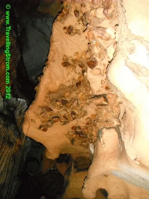
There was an information board inside the entrance which I read before heading deeper into the cave system. This was wider than the last one for the most part but there were some interesting rock formations inside. It was quite warm in there as well, very humid and this was the dry season, imagine the wet!!


Getting back up them steps took some effort on the return to the parking area. Riding a bike and drinking beer is not the recommended training for this outing, my heart was hammering and my legs were sore after getting to the top and stopping for a well deserved break 🙂


The actual track we walked on, and the dirt road we drove in and out on was all part of the Ho Chi Min Trail, the network of roads, trails, rivers used during the war for the movement of men and supplies into and out of Vietnam. This was the reason it was heavily bombed in this area.

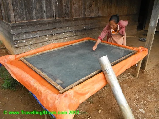
On the main road junction, we spotted a local lady making paper, so we stopped, asked for permission then watched how it was done [N19.55796 E103.39497]. The paper is made from bark, which is pounded to a pulp then boiled, it is then spread out on the screens with the aid of water and when lifted out and dried, is sold for people to use in temple offerings and ceremonies. On a good day this lady makes 30 sheets, we did not ask the price of them, although I was curious after we had already left. Here are a couple of videos, the first shows the pulp being splashed around in the water until there is an even covering before the screen is gently lifted out. The second shows a dried sheet being removed from the frame.


.
.
.
.
.
.
.


.
.
.
.
.
.
.
.
The next stop was a traditional Mhong village [N19.55890 E103.41756 ], here they also use whatever remnants of the war are available to either prop up their buildings or use them as herb gardens and in other ways. Just as we arrived and parked, we saw a beautiful girl in traditional dress posing for photos next to a communal corn grinding mill.


Here are a corn store and a pigeon roost, both using the casings from cluster bombs as stumps


An unknown building and a herb garden, both using cluster bomb casings


Drying corn by hanging and then some pumpkins on the roof, the vines have dried up, leaving the pumpkin behind


Here is how to grind corn with this communal grinding wheel
.
.
.
.
.
.
.
.
After we left here we stopped at a traditional Laos food restaurant at the next village for lunch. They have a range of vegetables or meat dishes with rice, just grab what you want, it only costs 15,00kip which is less than $2. I chose the pork dish, and then found out that every part of the pork is used, the meat is not sliced off the bone, the bone is just hacked through so you get to pick sharp bits of bone fragments before swallowing!!! When I mentioned this to the guide, he said Falang(foreigners) have stomachs made from aluminium, while Laos people have steel stomachs, so harden up m8!! LOL 😆 That last bit about harden up was not said by him of course 🙂

It still tasted all right though. After lunch we headed to a small Hot Spring which is right next to a river, here they have made small concrete enclosures where you can enjoy the ‘healing’ spring water without getting parboiled 😉 It was not very deep though and as I did not know we were doing this I did not have a change of clothes nor a towel, so I just enjoyed the scenery from the outside. The locals use this area as a pathway to cross the river so there was always some local people around as well.


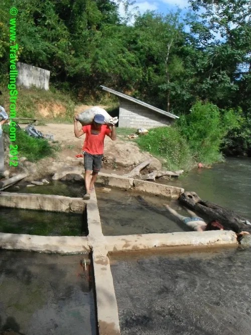


The ladies carry a lot of weight on the heads by using a strap, they develop strong neck muscles and can heft between 30-40kg, that is huge!!! We left this peaceful place and headed to the large cave called Piew cave. This was home to a whole village during the war and during the past week I had heard conflicting numbers about it. But, the cave was attacked by US fighters using rockets, they missed a few times, during this time most of the villagers went right to the back of the cave, then one rocket entered and exploded killing every single person in there. The official death toll was 374, but I have heard the number also being 450+. It took 3 days before the cave cooled down enough for the bodies to be brought out. They are still finding bone fragments today 🙁 As it turns out, we arrived on the 25th November, well it was on the 24th November 1968 that this happened and yesterday there had been a massive memorial ceremony at this site, hence the large amount of rubbish littering the area.

On the walk up to the cave were a number of blue signs indicating burial sites. Site # 1 was a bomb crater, this was used after the attack as a mass grave for those who were inside the cave. There were other sites here, showing where babies were buried. If a woman died and was pregnant, then the baby was removed and buried separately as they believe there would be no rest unless this was done.


The cave itself was hidden to start with but Napalm was used to remove all the vegatation, as you can see from the mouth, the cave was vulnerable from attack because of the openness on one side.

Inside the cave there is not much to see, it goes back about 40m or so and apparently this was the only area used, as they only used natural light and this is as far as it went. The cave itself goes a lot further back, but superstition meant they would not go any further. The floor is littered with discoloured rock and rubble and is now apparently 1m higher than it used to be.


We headed off back downhill and then had a to cross a very unstable bamboo bridge!!


It looks fine in a picture, but check out the movie.
.
.
.
.
.
.
.
.
We started to head back now, stopping at a cultural hall and then a house that is collecting old bombs, he has quite a few there and worth a fair few bucks if he ever sells them.


The final stop of the tour was the Bomb Crater Field, which of course I have already seen, and planted a Geocache at 🙂 We got back just before 6pm, and I had actually wanted a to watch a documentary they show here at 4pm, so of course I missed it. But, he was happy to play it again, it was about a group of pilots called Ravens. They were volunteers who flew FAC missions, or Forward Air Control, which basically meant flying slow and low until they spotted targets or they attracted fire, then they called in the fighters and bombers. They were never in uniform as this was a secret war and it was not until they were released from duties here and back home, that they wore uniform again. It was actually more a documentary about 4 old pilots who wanted to return and lay some ghosts to rest, 30 years after leaving Laos. I did not actually like this movie, as it seemed to glorify a group of people who took pleasure in killing anything that moved, women children, whatever, mostly civilians. But I have seen it now, so there is no need to see it again.
After this I headed off to Bamboozle! where I once again enjoyed a great meal, this time pork loin, chips and vegies 🙂


A few beers and rums here finished off the long day, tomorrow I really wanted to get on the road. It has been a interesting stay here in Phonsavan, I certainly learnt a few things that opened my mind, maybe I will come back, who knows.
Cheers from
TravellingStrom

cute dresses for juniors said
cute dresses for juniors
Piew Cave, Mhong Bomb Village and Other Tourist Attractions Near Phonsavan « TravellingStrom