50 Ways To Love Your Buddha
Posted by TravellingStrom on November 30, 2012
Mayan Prophecy Countdown
[gigya src=”http://www.clocklink.com/clocks/9001e-green.swf” flashvars=”TimeZone=GMT1000&Target=2012,12,21,12,00,59&Title=The End is Nigh” width=”288″ height=”24″ wmode=”transparent” ]
It was while I was thinking about leaving this town that I realised there were some Geocaches here. And, in fact, one of the Geocaches was at a place that Lorraine had told me about ages ago, but that was many beers ago and I had forgot 🙁 But, no worries, I now had a plan for the day and it involved a ride as well, although from what Lorraine told me it is a real shit road, but we shall see. I did not wear all the protective gear(tsk tsk I know), but just sand shoes and helmet, shorts and a shirt of course. It was a steamy hot day and through slow traffic I could not be bothered wearing it as I would have been parboiled!! I left after a particular nasty looking breakfast, the eggs were supposed to be soft but as you can see weren’t, and they were swimming in oil, so I left the whole plate and had the fruit and bread and jam. I think that will do it for me here for fried brekky!!!


Once on the move, the first problem I had was the GPS, for some reason the map section down near the river was blank, and that was where I needed to go(I found out later that I needed to remove a conflicting map and when I did that, this section popped into view, too late for me today though!) So, what I did was triangulate, I had the cache in as a destination and a line was drawn between me and it, I then needed to get myself down near the river and follow the river road until I reached it. The only way point on the way that I could use was the Friendship Bridge and once I had passed under that I knew I was on the right track.

This bridge is the one that connects Laos with Thailand, it is one of 4 that are open, with the 5th to be opened next June, that was the one I showed about a month back, prior to entering Laos for the first time. The road followed the river for the next little while and although the road was paved for the most part, it was an atrocious road to ride on, lots of big potholes, sections of pavement missing and corrugation as bad as the Mongolian Steppe!!! It was so crappy I did not even try and stop for a photo!!! After an hour to travel the 30km or so, I eventually got there and had a chat with a German Family outside for a short while before entering the park itself. Buddha Park [ N17 54.772 E102 45.869 ]


The park is just chock full of statues, around about 50 or so, but I never counted and it is a mixture of Hindu and Buddhist figures. A monk started this in the 50’s and was attempting to unite the two faiths. It is quite impressive, there are no info plaques anywhere, so I just wondered around looking and snapping pikkies, all the while working my way to ground zero.


This following photo has a very tall and skinny stepped pyramid structure, it reminded me seriously of the one in Tikal, Guatamala

Giant locust maybe?

Multi-headed elephant

Who knows?


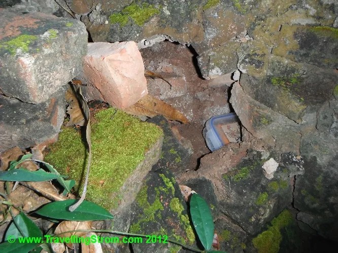
I had now come close to ground zero for the Buddha Park geocache, clicky link. It was extremely hot out here, so it made sense to find some shade and slouch and wait until the passing muggles were out of the way while doing a search. I am happy to say I found it, in the most likely place too, which is the best way when trying to find and hide, so there is less chance of others seeing 🙂

After this I continued on through the park until I reached this big onion shaped building, it had people up on top, so it looked like I would try that , it would have a great view of the park 🙂 But to go in, you have to enter the mouth from hell!!


Inside here are carvings and statues depicting the 7 levels from Hell to Heaven, and the stairways inside are very steep and with not too much light, it gets a bit hairy at times!!!


Eventually I escaped onto the structures roof through another tiny mouth and the view of the park was excellent 🙂


I was just about to head off, but changed my mind and went and grabbed some tucker at the restaurant there, basic chook and chips, but it worked for me 🙂

After lunch I headed to another cache, this one was planted by a local in a small village along the Mekong, and there was an opportunity to meet up if they were home, I thought it would be interesting to meet a Laos cacher 🙂 So I headed back to the blank area on my GPS map and once again used triangulation to zero in on it. It ended up being down a narrow lane way and near a large electric gate. There was nobody home, which was a shame, but I did find the cache, so not all was lost 🙂 The cache is called Ban Bo-o , that is a clicky link once again.


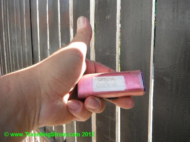
Not a bad effort, two attempts and two finds 🙂 Next on the agenda was number three, this one was in town so I had left it until last. Once I got back into to town my GPS map was back on known ground, so that was all good. But I probably would have found this without it as there were signposts to the That Dam clicky. This is a revered Stupa and many locals believe it is inhabitated by a 7 headed Naga, but I never saw one so I cannot comment on that. By the way, THAT DAM is pronounced TAT DAM.


So, I found this one as well, a good outcome for the day 🙂 So, I headed back, logged my caches and went back to the Spirit House for my favourite tucker, or tapas as they seemed to be, not a big heavy meal, just right for this climate. Oh, and washed down with quantities of Beerlau 😉

Cheers from Vientiane
TravellingStrom

Leave a Reply