Friday – Still in the Gibson Desert, Western Australia
Well, we survived the howling dingos and whatever else the night brought around and woke to a beautiful sunrise 🙂

A quick breakfast before packing up, which was a bit tricky as there were lots of buggy things around hiding under the wet tents, I am not sure which end is which here, but I am sure it does 🙂

It was already getting warm as we headed east, the road was not too bad for a change and we managed a pretty good speed to start with, but knowing that would change for sure. Along this road we have seen many dead and abandoned cars, I stopped counting at 100 as I could see it was a common practice out here.


We found out later that what happens is, the local people drive the car until is breaks down, they then strip it for parts if they are useful or just burn the car. They are a blot on the landscape out here and really spoil a pristine view, well except for the road carved through the bush I guess 😉 We stopped at a Telstra tower, but there was no service, it was microwave only and then found some yucky road, with the wind blowing a bit, this was a bit tricky, but we eventually made it to the first cache for the day, where we had to clamber up and around some bluffs, but we did find it 🙂 From up there we could see the caves across the road and excellent panoramic views, great stuff 🙂


It was my lead still when we continued on and I was a bit ahead when I came around a corner and spotted a big bull camel in the middle of the road! My first wild camel and he was huge, so I grabbed a quick movie of him and then a few still shots, he was a tad nervous and bolted down the road before swerving off and heading up into the dunes.


Not long after this we came to one of the many interpretive sites along the Outback Way, and it just happened to concern camels, so we stopped for a snack and a read, very interesting, especially the spiders!


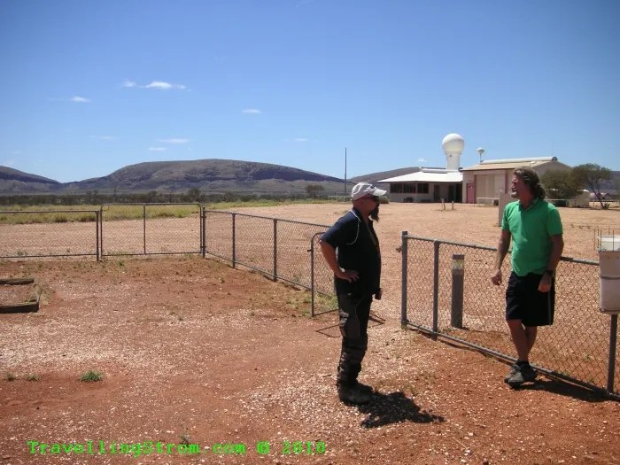
A few hours later after another cache find we managed to survive some loose surface and arrived at the Warburton Community, or to be more exact, at the Giles Meteorology Station as it is not allowed to enter the Aboriginal Community itself without different permits, we only had transit ones. Here we parked in the shade of the enclosure surrounding the Gunbarrel Grader, a very tough piece of machinery.


There was also a piece of the Blue Streak rocket and we were met by Mike, the manager of this facility. Derek knows another biker who used to manage this place, so they had been warned we were arriving 🙂 Mike gave us a great tour of the facility, thanks very much 🙂


First stop was the weather office, here was the radar tower and control point for the station and all the data collectors. We were shown some of the data gathered by the weather balloons and also the hydrogen plant next door which splits water to make hydrogen used in the balloons, a bit dangerous, but they have all the safety gear and procedures, plus it is well away from the living quarters. There are actually 4 officers living here for a 6 month stint and they can bring their wives if they want, that is if the wives want to be stuck out in the desert for that length of time!


Out the back were the actual data gathering instruments, inside a fenced off compound, but mainly to stop animals from walking over them. There were a number of barometers, temperature gauges, a glass ball that measures the amount of sunlight there is during the day and a water evaporation pond.


More temp gauges in the ground to measure different depths as well as soil surface temperature, two rainfall gauges and on the fence behind Mike is an isotope gatherer. Apparently when it rains, this water is collected and sent to a lab for testing, the radiation from events in other places in the world can be found using this technique.


Just behind Mike is a colourful little radar dish, this is the old radar mount used to track the weather balloons when launched 3 times a day. This was a manual system and the operators could spend up to 3 hours in here each time, not much room in there either!


After the tour was finished, Mike invited us back for the 3.40pm launch of a weather balloon, so all we had to do now was work out what time it was!!!! There are actually 3 time zones in this place, WA, SA and NT, the weather station works off SA time, which although it is in the center of the country, it is actually half an hour ahead of my home town on the east coast, very weird people South Australians!!! West Australia was the time we were on, but now the local time is actually Northern Territory time, so what to do, very confusing. Well, we had lost about 2 hours coming into SA time and missed lunch, so we bolted down to the roadhouse where we booked a campsite and got the tents set up. They had power here and a great camp kitchen with everything we needed, including fridges and a microwave.


After this and a quick snack we went back up to meet Peter, who was going to show us the launch of a weather balloon. We just arrived in time as he was inflating the balloon in the shed. This area is saturated in water prior to and after the filling to stop the build up of static electricity which could cause another Hindenburg episode. Once inflated, the radar reflector is tied on to the neck. The launch this afternoon is not a full sized balloon, it is only a small one and they are only getting wind speed readings, the full electronic package ones get launched in the mornings and late evenings, but this suited us 🙂


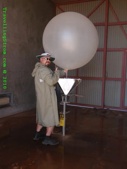
After the filling we went back inside where Peter showed us how the radar was calibrated for tracking and he showed us one of the electronic packages used in the larger launches, they measure temperature, humidity as well and transmit the info back down. The balloons themselves can get up as high as 30kms before bursting and that is when tracking stops. All around Australia at the same time, these balloons are launched and the data collected and processed somewhere else. The other thing he showed us was the tracking scope, this is outside and is used once the balloon is launched. It is slaved to the radar and it needs to be pointed at the reflector under the balloon and when the radar has locked on with a steady tone, it is now automatic and will follow it until it is shut down. I took a small movie of the launch, which was straight into the sun, but interesting anyway 🙂


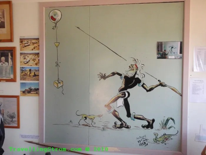
There was a small museum with some information about the station and the area, including a painting by Len Beadell, the engineer who built these roads. A bit backwards I know, but I finally took some photos of the info board out the front of the station, better late than never eh 🙂


After this we returned to the camp ground past the car graveyard and settled in, this is only a small fraction of the amount of cars seen along this road and it would be nice if they were all here!


It had been mentioned that there may be WiFi internet here at the road house campsite, wonders of wonders there was and it was free and quite a good speed as well 🙂 We managed to stuff up the times of course and when we went to the roadhouse for dinner, they were just closed, but lucky for us, he had all this cooked food that had to be thrown out, so we had some deep fried free food for dinner 🙂 The rest of the evening was spent in the camp kitchen, totally screened from flying bugs, mostly grasshoppers out this way. I was doing a blog entry and uploading a stack of photos while I had the chance and also chatting to another couple who were heading west, this is Stephanie and Servaas from Gent in Belgium. Nice to meet you and safe travels, I may see you in Belgium in a while, during the next leg 🙂

It was a quiet evening all up, as it is a dry community and we could not leave early in the morning now because the store does not open until 9am and we had forgotten to fill up with fuel this evening, oh well never mind, play it as it comes 🙂
Day – 199 km and 124 miles
Trip – 6,471 km and 4,021 miles
Cheers
TravellingStrom
WORLD 