Friday – Shelbyville, Indiana
Hi everyone, I need to clear up some confusion, so I will do it here and now.
I am receiving a lot of offers of help, chat, food, rides, beer etc and not in that particular order either 🙂 I appreciate all of the offers and I apologise to those who I have missed or gone past without dropping in to say G’day. I always acknowledge and answer all messages, whether they are emails, comments here, PMs from forums or whatever. The only issue seems to be, I sometimes get them after I have been and gone in certain areas. So, to make things a lot easier I will outline a few facts on where I am, where I could be heading and an explanation on what you see here.
For a start I am always going to be behind in the blog, usually two days, maybe more if I do not have net access. So what it says as the date, place etc at the top of the page is out of date, ignore it, it is correct for the time I was there, but I am not there now 🙂 For example, I am writing this in South Bend, Sunday the 21st June, the first day of summer in the US.
There are two ways to know where I am and which way I am going. Look to the left and down a bit, there is a small map, it tells you my current general location. Whenever I get internet access I update this, it takes 30 seconds and is as actual as it can be. If I do not do a blog update, I will always update this map anyway.
The second way and most accurate is to look to the right, there is a link called
Here I Am
SPOT tracks of Where I Am
Click on that link, it will open a new page in your web browser, if I am actually physically riding at the moment, it will be updated every 30 minutes or so, the higher the number flag is the latest position locator. I always turn this off about 5 minutes from where I intend staying, but I am in that general area.
I hope the confusion does not stop the offers of meeting fellow riders from coming in, but now I may get the messages before I actually blow through town. After Rapid City, I will be slowing down a lot more, so I will have more chances anyway.
Sorry for the long introduction, but this will stay here for at least a week, so if you have read it once, scroll down for the days update, which starts with the non bold text 🙂
I got a couple of email responses this morning about how work commitments were in the way , well it was a week day, so it is my fault for turning up at the wrong time. I watched the weather channel, there is a system out west, heading my way and it is all bad for the next few days at least. This also was explained in some emails. Hmm, what to do, OK, I had not been to Kentucky, down south, nor Michigan up north, pick a direction.
There had been some severe thunder bumpers and a lot of rain overnight and during the morning, so I put off leaving as long as possible. There was nothing much near here, so it was no good staying another night, in the end I packed up in light rain and decided to go visit some state borders and get some photos 🙂 I might as well achieve something for the day.


I headed south towards Cincinnati, I figured I could get a Kentucky state sign down there somewhere, then grab an Indiana one out west and then make tracks north for an early start tomorrow on getting one of Michigan.


As I negotiated my way around the ring roads of Columbus, road diversions forced me in a different direction and the traffic had slowed to a crawl 🙁 I had to go a different direction and do a loop to get back to the turnoff I needed, that was when I saw the reason for the delay, a beer truck had rolled over on an on ramp, he must have trying the stock, I wonder if they breathalysed him 🙂

After getting past this nightmare I headed south into extreme heat, I still had on all my wet gear, but the skies were clearing up and it was getting warmer every mile I travelled south, and steamy, I thought Florida was bad, whew!
I stopped for some Wendy’s for lunch, in the nice aircon, here I looked at my atlas again and on further research, decided Cincinatti would not be an ideal place for a state border photo, it was on a river, in fact as I looked further, the whole north and western border of Kentucky was river, which meant I may not get a photo, as I could not stop on a bridge, could I? Hmm, OK, I stripped down to normal riding gear and changed course to Maysfield, it looked small enough that I may be able to stop on a bridge. On the way I stopped at a store to stock up on tucker, cheap but filling 🙂


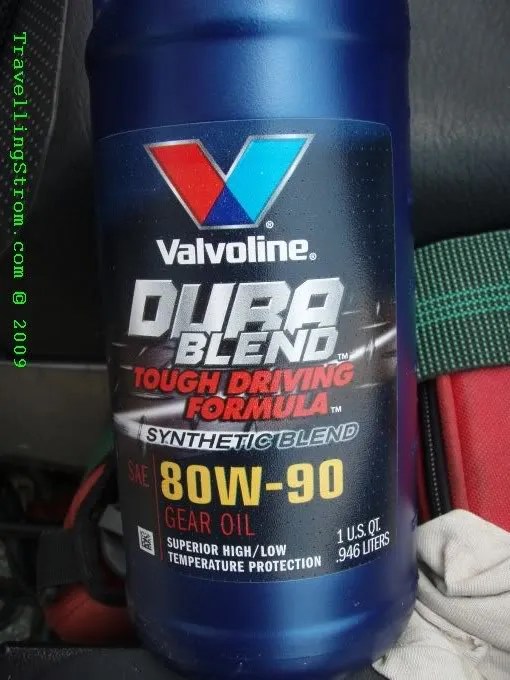
Now, I had received another reply from Heiko at CLS about may chain oil. He had said, use a gear oil, synthetic and at least 90 weight. So, I tried a small town auto shop and picked a litre bottle of this stuff up, it seems to fit the bill and I promptly stripped the seat off and filled my reservoir.

It would take a little while for the air bubbles in the line to come out, so off I go and finally got to Maysfield, this is not a small town and the first bridge I came to had the state sign right across the span, nowhere to stop. The 2nd bridge did not even mention it, hmm what to do?


I decided to follow the river but the roads were hard to find and they had no bridges anyway. The roads were nice and tight with not much traffic, so that was a relief.

OK, next bright idea is to go across into Indiana, but go below Cincinnati, and see if I can pick up a sign there, this took a while to do and after a bit of riding around a small border town, I asked some people and they said no, there is no border sign except up on the slab 🙁 So as it was now after 6pm, I headed north, after grabbing this crappy shot, it was not much result for the days effort, reminds me of my fishing trips 🙂

I spent the next hour or so trying to find a motel, the skies did not look all that bad really, but I did trust the storm and tornado warnings, so a tent was not on my agenda tonight.

I eventually found one after back tracking from a nowhere town and ended up in Shelbyville, it was on the way to Michigan, a state I would try and get a photo of tomorrow, or so the plan was at this time, how things change 🙂
I checked emails after a late dinner and I had missed a few people apparently, well that was the reason for adding the intro to today’s posting. I also spoke to a chap called Art, he was in Ohio, from where I had just come from, but he had offered steak, beer, a bed, a ride and also a place to do an oil change, I was due within 500 miles. After discussing a few things with him, I decided I would ride back tomorrow, it was only a few hours away after all and I would arrive early afternoon, I could do an oil change and have a relax maybe 🙂 I could still get to Rapid City on time without pushing things, and the oil change was essential. So, I had a Friday night relaxing, no beer dear and had an early night for a change 🙂
Day – 408 miles and 657 km
Trip – 19,476 miles and 31,344 km
Cheers
TravellingStrom
