Saturday – Organ Pipe National Monument, Arizona
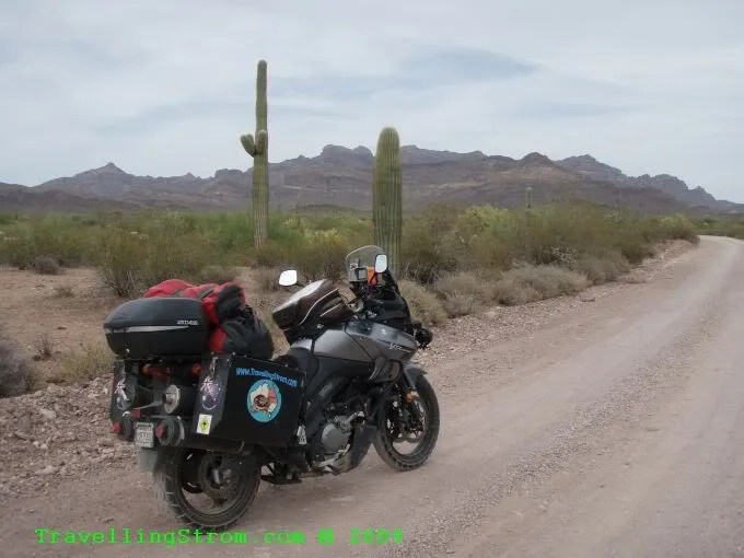
TravellingStrom bites the dust today, no damage done though, just a bit rocked over
I did not get lost leaving town, but as I had a direction planned out, when all the signs say all these exits on the interstate are closed, well, things became a bit confusing. You see, I had the small map for the Desert Museum, it was just west of where I was, but to get there I had no address, just directions. It had a few street names and mentioned the I10, so when I got on the I10 and the exits are not useable, well, spanners in the works etc come to mind!
I eventually tricked the damm GPS, I got off the highway and rode somewhere, I have no idea where, then I asked it to take me there and it did, hooray 🙂 There were a lot of small ranchette type houses all spread over the hills around this area. I eventually got to the desert museum, but decided instead, I would go to the Saguaro National Park.


As you can see, there are other cacti around, quite a lot in bloom as well, spring is a good time to see that I guess 🙂


This seemed the place to ask about the disease that seems to be affecting the cactus, but when I asked the ranger lady, it turns out that that is normal. The age of the plant is the cause, and the lower sections go all woody and like bark, also the holes are caused by woodpeckers and other birds, so that was good to know!
I went on a small ride around a nature trail, it was dirt and a bit corrugated and sandy in patches, but not too bad and it was only a few miles long. The interpretive panels were quite good as it saves me having to type 🙂 The Sagaura cactus is pronounced Sar-Wear-Oh, or Sarwearoh, the G turns into a W sound, weird.


I could see all the flowers at the tops of the cactus, but not real close cos I am short, but eventually I found a shorter one in flower at a good spot, with a rock in front of it showed up. The flowers don’t all bloom at the same time, they are staggered.


A few showing the road and the general area


Then a real weird shaped one next to the road, like it was boxing 🙂 You can see the washboard effect in the road as well.

This is the skeleton after the thing dies, a very woody material.

Now this I did not expect to see, deer in amongst the cactus!

After that little side trip I headed west, to the Organ Pipe Cactus National Monument near the Mexico border. On the way I stopped for some lunch and saw what appeared to be a telescope dome up on the hills, well up the road I saw a sign for Kitts Peak observatory, you can see the white dome on the top.


Now, this road was not very spectacular with scenery, nor did it have many trees or bends, but what made it very depressing was the huge number of death markers along here, I must have counted over 30 different memorials, some had multiple crosses on them. The first one here is an 11 year old girl called Michelle, another was just next to it and a 3rd was in the bushes a bit hidden away.


This next one a bit further up had soft drink cans as gifts I guess? They were mostly all very clean, well maintained but I have no idea of the age of them, this could be the last few years, or the last 50?

So, around 2.30pm I finally arrive at the visitors centre, you can tell why they are called the name 🙂 Apparently they are really prevalent in Mexico, but this park has them well established and the only place in the USA where they are natural.


Now, if you look at this next map of the park and the roads inside them.

I am in the visitors centre, I wanted to do the dirt road to the left called North Puerto Blanco Drive, this went all the way west, down to the border and back east to Lukeville, which is the border control town, then back up and camp at the park. Well, no go, that road is closed, too much drug running and illegal aliens in that area and too dangerous, that will be explained further tomorrow. Never mind, on the other side of the road was a paved road by the looks to the Ajo mountain drive, that is Ahh ho mountain. The girl explained about camping and said there was another one a bit back up the road which would be very quiet, no running water though. I decided to do this ride, then decide where to camp and if need be, fill up with water here before I left.
Off I go and find right away it is dirt, rough as guts as well, but no worries I can do it 🙂

Now comes the moment TravellingStrom bites the dust 🙁 I had stopped to read this information panel.

When I had finished I turned around and neat as can be, fell over this damm great fricken rock, where did that come from? I landed on my hands and rolled, but due to the fact I had all my gear on, I did not get hurt, a bit sore in the wrists. I did not see it because my helmet was still on, lol, well, I did say I hit the dirt, not the bike. Well, maybe 3rd time unlucky, maybe next time we go down together eh! Preferably not at all of course!
Well, the next photo in sequence tells the story of the next hour or so. Come for a ride 🙂


They were nice though and added some bitumen to the steep parts of the road, I guess to stop the cagers digging ruts.


It did not last though but I got to the Arch Canyon about 40 minutes after starting out.


From there on back to the start point, I did not bother to stop much, the road deteriorated and I was constantly dodging rocks sticking up, or washouts and stuff like that. The corrugations were the easiest part, which is unheard of for me to say that!

I can honestly say the last 10 miles were not good for sightseeing, it could have been real nice scenery, but I can’t tell you as I was concentrating too hard on the road. I did enjoy the ride in a strange way, but the road spoilt the scenic ride, if you know what I mean.
I get back to the road at 4.45pm and decide to go find the other campsite, now on the way back up the road I had to pass the border control people again, there are a few patrol cars hidden away, but up on the hill to the left, that is not a cactus, it is an aircon vehicle with camouflage with telescopic arms with remote cameras on them, probably heat detectors as well. They are not good photos, but I did not want to draw attention to myself as I had no bike insurance at the time.


I nearly went all the way back to Why, the small town 17 miles north and could not find the turnoff to the camp, so I thought bugger it, I will camp at the visitors centre site, at least they have water and although I had filled up after the dirt ride, more is better 🙂 I found a tent site, plenty to choose from, once again, end of season down here, it is getting too hot and pitched the tent. I intend getting a better tent, this is too small, so although this was free from Bill, he did say if I was not happy to dump it, it is 20 years old.
I actually want a free standing dome tent, this one is too fiddly getting it together, but I can say I have tried it, it is just not suitable.


While I was looking around I noticed this large hole about 10 feet from my tent, I wonder what comes out of there during the evening? The signs and guide book does mention rattle snakes and Tarantulas, did I mention I hate spiders!

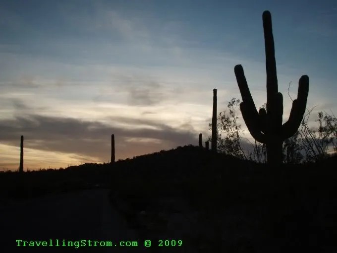
After a bit of dinner and saying G’day to a neighbour called Brenda, I took a few sundown shots, just for something to do.


There was a small group of Harley riders camped just down the road a bit, they went passed about 5.30, probably heading to Lukeville, the border town for a few drinks, it was Saturday night after all. I thought about it, but decided not to, there were too many border control and normal police around to get booked DUI without any insurance to boot, so who needs it anyway. They turned up a lot later and had a bit of a carry on. I mentioned they had running water here, no showers, but the running water at least allowed for a sort of body bath, better than nothing I guess. I did not stay out of the tent too late after dark as I was a bit unsure of the natives what! So, I read a bit of a book and crashed quite early for a change. I had expected, as it was a desert, for it to be cold, but it was relatively warm during the evening.
Day – 260 miles and 418 km
Trip – 5,895 miles and 9,487 km
Cheers
TravellingStrom
Go to top of page