Saturday – Dumas, Arkansas
I ended up in a real dump this time, but I got a mirrored ceiling
I headed south today, depending on how the day progressed, I may be into Louisiana but there is no point in pushing it, so see how I go. There were some scenic roads down south of here, so my plan was to join up onto those. First off was to head east to Salem, before heading south to Batesville and Bald Knob.

There was some road works happening before I got to the lake, after that I was caught behind some cars, no fun.


The only way to fix it was to stop and wait for a bit, until the next car came from behind then launch it 🙂

In Salem you can see what I meant about Memorial Day, a lot of people were or had been about sprucing up the graves.

I have not seen any dead ones of these, so I am guessing people try to avoid them, but I have seen hundreds on the roads from Oklahoma through to here, this was only a tiddler.

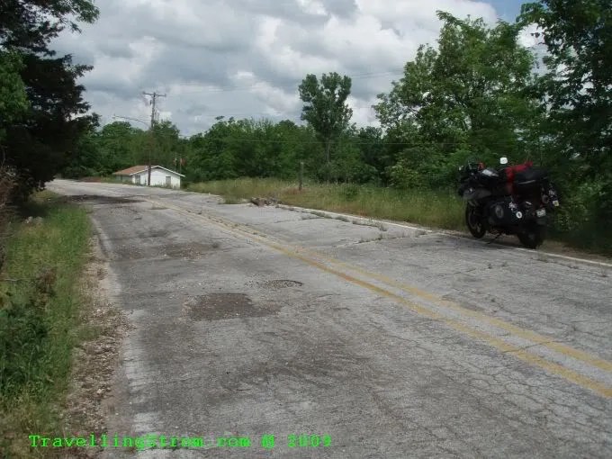
The only trouble riding through this type of country is there is nowhere to stop for anything. The roads are narrow and cambered wrong with soft edges and when you find a driveway, it is not where you want to stop as there are usually people there. So, I was lucky to find this old bit of highway, now unused where I could hide out of view and park the bike safely, still a big worry about it falling over. A good place for a snack etc and another read of the atlas, just for bearings.
I took a few photos of the new helmet quick release thing I bought, it works real good. You can see the original double loops to the right, this unit just uses the same web loop that the metal loops are in.


I use the GPS to get to city centres, but before getting to them I am looking for highway junction signs and follow them near cities, it turns out a lot faster as I bypass the traffic. But, I get to see some not so scenic sights instead, swings and roundabouts. This is Batesville 🙂


It was not long after that I saw my first (and only as it turns out) animal warning sign in the whole of Arkansas! They need to save some money and buy some more for the mountain country, not down here on the flat where they make a lot of hay.


Between Batesville and Newport is a small town called Oil Trough, I can tell because the name is on the traditional water tower( I will have to remember to take photos of where I am so I can keep track). Now, there was a restaurant here, but I am not intending to try the menu at any time soon, yuck!!!


A lot of this area is pure agriculture and although some paddocks are planted, some are still being worked for a late planting I guess. It was starting to look like rain as well, nothing major at this stage though. In this first photo, there is a real weird patterning to the way the field is set up. There are all these small earth berms curving across the field and this is repeated in numerous fields around here?? It may be hard to make out though.


I eventually had to pull over along a farm track to get the wets on, it was persistent enough to be annoying by now.

Hello, what’s your name 🙂

Well, the rain lasted a short while but kept threatening, so I left the gear on, but now I was getting quite warm and baked, so I had to stop for a layer change. It looks like being one of them days. The one good thing about all the churches is that they have good driveways and places to park, keep that in mind for next time, a lot better than sandy farm tracks, except it probably is not good form to have a pee here 🙂

I can remember a few weeks or so back a lot of water was dumped in these regions at the beginning of spring, with floods even, well I can see the remaining evidence of it in some areas, the rivers are still high.

The farming lands have now turned to swamp lands with the road up on a levee type thing.

Yep, it started to rain again!

More backed up run off channels, a full river and some waterlogged crops.


Now, this a clearer photo of what those fields of berms were about, it is actually a water management system and they must use flood irrigation which runs around all the berms before finding the small exit passages to the next berm system. Those little yellow things are plastic bags to stop the water eroding the berm at the run throughs.

Cool, it looks like a ski jump bridge ahead, this is over the Arkansas river near Back Gate and this river runs into the Mississippi.


By this time I am sick of riding in the wet so I looked for a cheapish motel in Dumas. I talked the guy down in price and took one as the rain looked like it was going to get heavier. It was not the most salubrious neighbourhoods, but it did the job, so I thought at the time. I ended up getting some deboned chicken wings and some beer and staying in out of the rain as the town was too small to have a bar, but it had about 15 take away food joints, go figure!


After looking at the door locks and a real look around the room I noticed a few things that are not normal, the mirror above the bed and the Black light on the bed head, although there was no coin box or vibrating bed machine, thank my lucky stars! Oh well, it could have been worse! Hey, for all those Queenslanders out there, remember Dr Death, old Patel from the Bundy hospital, well here is a funny thing, at a whole stack of motels that I have stayed at for the last month or so, the owners/managers/franchisees have been Patel’s as well, it must be a real common name, but I always think of Dr Death when I book in for some reason 🙂


Day – 307 miles and 494 km
Trip – 10,397 miles and 16,732 km
Cheers
TravellingStrom
Go to top of page