Day 57 – 14th October
Posted by TravellingStrom on October 14, 2008
I nearly froze last night, I woke up and had to add more clothes again, I probably need to put on a layer of fat, all over though, not concentrated in the middle like it is 🙂 Because of that I stayed in bed late and did not get moving until after 9.30.
My original plan for the day was to head to the Great Ocean Road and do that and head back up and west in a few days. The wind was howling from the south though, so I needed to get out of the wind and away from the cold, easily said. I headed west and nearly stopped at Puckapunyal, which is the military test area, (the grey area where I drew some black lines) but they had a tank museum which at $14 was too costly for a few bits of old iron and I was not that interested anyway, so I continued on as everything else there was off limits to the general public.

One thing I did have my eye on out this way was a place called Hanging Rock, I asked the guards at Puckapunyal and they said yes, it is the place the movie was made, so that was good. That was my next destination. So, to get there I had to head west to Tooborac, south to Lancefield, and west to Newham and then take the Mt.Macedon road to Hanging Rock itself. The roads were very rural but well maintained, it would have been more enjoyable still, without the howling headwind, but I managed OK.
Except, I seemed to have taken a wrong turn somewhere near Newham and ended up here 🙂 What a shame I don’t drink wine.

I turned around and headed back and saw this old Furphy in the front yard of a property, last one I had seen of these was in the Longreach Hall of Fame.

I eventually got onto the right track and saw my first view of the Hanging Rock outcrop.

It costs $8 for motorcycles and you don’t pay to get in, the boom gates let everyone in, it sucks you in on the exit though, no chance of tailgating, them gates work very fast and you need a barcode from the ticket to get out, very sneaky 🙂

First up there was a bit of a background centre on the area with its geology and history etc, they also had a display outlining the film Picnic at Hanging Rock with a few sculptures.


Then it was on to the walking track itself, quite steep and freezing, but it did not take long to warm up and I had shed my beany, gloves and opened my jacked by half way 🙂
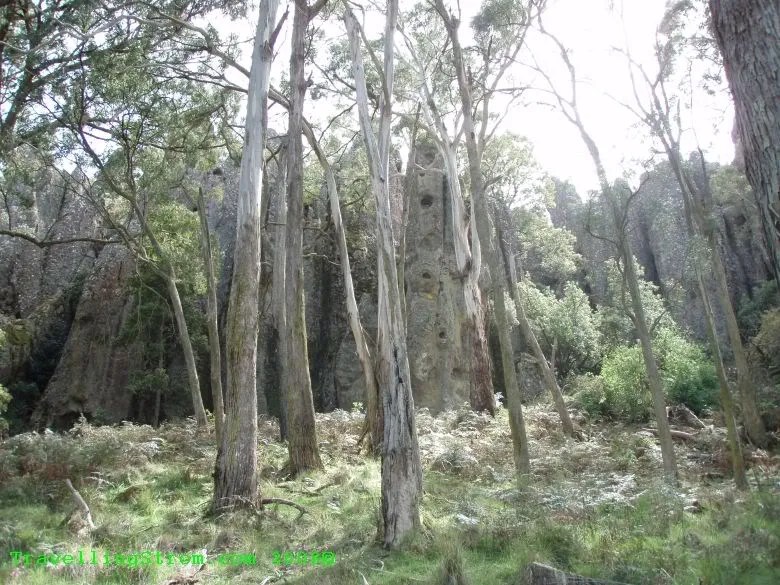

I had a choice, head to the summit by path or Hanging Rock by steps, I took the path as steps would be easier downwards , There were some interesting rock formations, all volcanic of course.


The views were excellent as well.


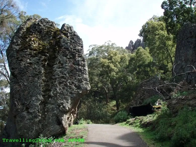
There seemed to be a lot of rocks that could be called hanging that I saw, including these.


But, it was not until I descended the stairs that I came upon the one and only Hanging Rock, it was quite big as well and you have to walk under it. This is one of the pinnacles that has fallen over.

Just at the bottom is a place called Morgans Blood Waterfall, the growth on the rocks must be a more vivid red when wet, but it still looks like dried blood when dry.

It turned out to be an interesting day from a slack start, the movie was great when I saw it when it first came out and of course the mournful sound of the Pan Pipes in the soundtrack bring back memories. I did not experience anything weird up there, but I can see how easy it would be to get lost for a while, everything is very confusing as it is and they have all these pathways and signs etc.
Then, after purchasing my exit ticket I headed for fuel at Woodend, this is where the school was where the picnic started out, only a few klicks down the road. I checked the visitor centre; I was looking for a warm dry out of the wind spot and was directed towards Daylesford. I headed in that general direction, it was still cool and windy but I noticed as I headed more northwards it was getting warmer so I decided to work that way.
I spotted this sign, very small tourist sign indicating a place called Cricket Willow, I had heard of something like this, if it was the same place, it where they grow a tree called Bat Willow, the wood is used to make cricket bats. So, I headed up this tiny narrow winding road and eventually found it, but it was closed for a while, the lady had to go out, bummer. She said the tours do cover everything and there was one on the next day at 1pm. So, I saved the location in the GPS and headed off.


I headed north again and via some nice country roads arrived in Maryborough. They had reasonably cheap internet there so I spent an hour or so paying bills and checking emails etc. They had a block on U-tube though, so I could not upload any more videos, bummer!
These old cars were doing a rally or something in the area and were concentrated around the Visitors Centre where I was.


I then found a caravan park that was a bit sheltered from the wind and relaxed for the evening, finished watching John Hancock etc. I even had an ensuite private toilet, shower, but only rocks to sleep on.

I also had a chance to check my oil, sort of anyway as I was by myself, I could not see anything in the sight glass, so I added, checked, added, checked until I had used up the extra 900ml I had spare. I think it is at the bottom of the sight glass now, but can check when I get to Peters place on Thursday. I am due for another oil change soon anyway.
Day – 227km
Trip – 19,948km
top of page
Leave a Reply